
REVIEW · OAHU HELICOPTER TOURS
30 Minutes SHARED Helicopter Tour in Honolulu
See Oahu from a much better angle. This 30-minute shared helicopter flight packs Honolulu’s coast, mountains, roads, parks, and landmarks into one compact ride. I like the maximum-three-person group and the pilot commentary, which make the flight feel more personal than a large sightseeing outing. The main drawback is time: 30 minutes passes quickly, and $319 per person is a serious expense for a short activity.
I also like the choice of a doors-off flight, when available, because it gives you a clearer view and better photo opportunities. Pilots including Scott, Stefan, and Jacob have earned praise for friendly service and smooth handling. Still, weather can cancel the trip, and the route naturally spends only a short time over each sight.
Key points to know before booking
- A three-person maximum keeps the flight intimate, with a better chance of seeing clearly from your seat.
- The route covers both Honolulu and central Oahu, from Waikiki and Diamond Head to Moanalua Gardens, H3, and Aloha Stadium.
- A doors-off option may improve photos, but confirm the setup and any related requirements before arrival.
- The pilot’s running commentary adds useful context, especially over places that can look similar from the air.
- The $319 price buys a special viewpoint, but the short duration means this suits people who value the experience more than a long sightseeing session.
- Free cancellation applies up to 24 hours ahead, while bad weather may lead to a new date or full refund.
Taking off from Honolulu International Airport
The tour begins and ends at 1 Lagoon Drive, Honolulu, at HNL. That location matters because you are not spending part of the flight reaching a distant airfield. You arrive at the airport meeting point, take the helicopter ride, and return to the same place.
The flight lasts about 30 minutes. That is long enough to see a broad sweep of Honolulu and several inland landmarks, but not long enough for a relaxed look at every point on the route. I would think of it as a fast visual tour, not a slow aerial survey.
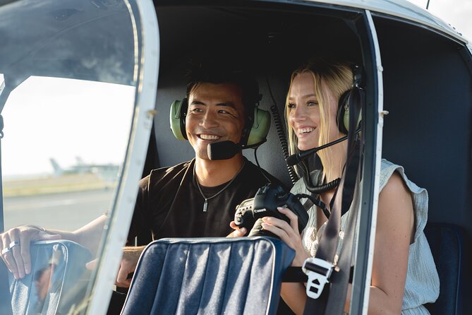
The aircraft is described as a small four-seat helicopter, with no more than three paying passengers on the tour. That is one of the strongest features here. A small cabin can make the experience feel less like a group attraction and more like a private outing shared with a few people.
An aviation headset is included, so you can hear the pilot during the flight. A cell phone lanyard is also provided, a practical touch when you are trying to take pictures in a moving aircraft. The tour is offered in English.
Each passenger has a total weight limit of 300 pounds. This is important to check before booking, especially if more than one person in your party has a larger build, since aircraft weight limits can affect seating and departure decisions.
A few more helicopter flights around Oahu worth a look
- Oahu: Magnum PI Hughes 500 4-Passenger Doors-Off Helicopters
★ 5.0 · 1,372 reviews - From Honolulu: Oahu 60min Helicopter Tour with Doors Off/On
★ 4.9 · 410 reviews - Oahu: Helicopter Tour with Doors On or Off
★ 4.9 · 221 reviews
Honolulu Harbor, Sand Island, and the first coastal views

The flight includes Sand Island and Honolulu Harbor near the beginning of the route. From above, the harbor gives you a useful introduction to how Honolulu functions as a working port, not just a beach destination.
Honolulu Harbor, also known by Hawaiian names including Kulolia and Ke Awa O Kou, is the main seaport for Honolulu and the state of Hawaii. From street level, much of this area can feel enclosed by buildings and roads. From the air, the relationship between the waterfront, port facilities, downtown, and nearby parks becomes easier to understand.
Sand Island adds another change of scenery. It is part of the industrial and harbor side of Honolulu, so this portion will not look like the postcard version of Hawaii. That is a strength if you want a fuller view of the island rather than only beaches and hotel towers.
The pilot’s commentary helps here. Aerial views can go by quickly, and a short explanation can tell you what you are seeing before the helicopter moves on. I would listen first and photograph second, since it is easy to spend the whole flight staring at your phone.
Ala Moana, Magic Island, and Ala Wai Harbor
The route then takes in Ala Moana Beach Park, Magic Island, and Ala Wai Harbor. These places sit close together on the edge of Honolulu, but the helicopter gives you a clear sense of their shapes and connections.
Ala Moana Beach Park covers about 100 acres and includes a wide, gold-sand beach more than half a mile long. From above, the park’s open space contrasts sharply with the dense city behind it. You can also see why this area is such an important break between downtown Honolulu and Waikiki.
Magic Island is a man-made peninsula beside Ala Moana Beach Park and the Ala Wai Yacht Harbor. It was created in 1964 for a planned resort complex and later became a park. Its official Hawaiian name, ʻAina Moana, is used less often, so the pilot may help you place both names.
Ala Wai Harbor is Hawaii’s largest small-boat and yacht harbor. It sits at the mouth of the Ala Wai Canal, between Waikiki and downtown. From the air, you get an especially clear view of the geographic divide: Waikiki and Diamond Head to the east, with Magic Island and the Honolulu waterfront to the west.
These are excellent photo areas because water, boats, shoreline, parkland, and city buildings appear together. The tradeoff is that the helicopter will not hover over each place for long. You need to be ready when the view opens.
Waikiki and Diamond Head from above
Waikiki is likely to be one of the most memorable sections of the flight. Its high-rise hotels line the shore, and the famous beach forms a narrow strip between the built-up district and the Pacific.
From ground level, Waikiki can feel crowded and highly developed. From above, you see the curve of the beach, the hotel blocks, the nearby Ala Wai area, and the larger shape of Honolulu in one frame. The view gives you a useful sense of scale that walking along Kalakaua Avenue cannot provide.
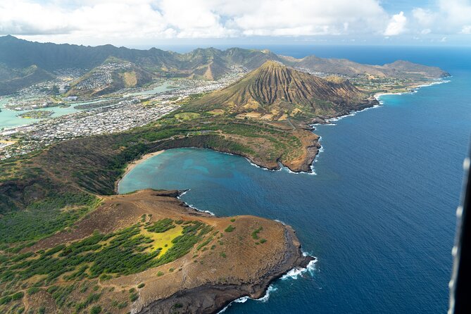
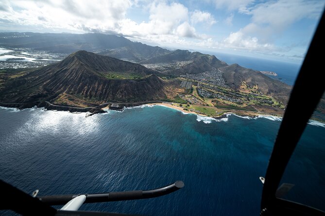
Diamond Head, known to Hawaiians as Lēʻahi, is another highlight. This volcanic tuff cone has a distinctive ridgeline that resembles the dorsal fin of a tuna, which is likely the source of its Hawaiian name. From the helicopter, you can appreciate the crater’s form without making the hike to its summit.
I would not treat this flight as a substitute for visiting Diamond Head on foot. A ground visit gives you trails and close views, while the helicopter shows the whole volcanic formation and its position beside Waikiki. If you are deciding between the two, the flight is best for broad context and photographs.
The Diamond Head section may also be the busiest part of the route visually. Waikiki, the shoreline, the crater, and the surrounding neighborhoods arrive in quick succession. Keep your camera ready, but do not miss the view by focusing only on framing a perfect picture.
Same place, a different flight path:
- Private Oʻahu Helicopter Experience: All Window Seats
★ 5.0 · 209 reviews - Oahu: Path to Pali 30-Minute Doors On or Off Helicopter Tour
★ 5.0 · 104 reviews - Private 60 Minutes Helicopter Tour in Honolulu
★ 5.0 · 91 reviews - Blue Skies of Oahu Helicopter Tour
★ 5.0 · 50 reviews
Waialae Golf Course and Honolulu’s city center
The flight continues past Waialae Country Club and into the central Honolulu area. Waialae is a private club in East Honolulu with a par-72 championship course designed by Seth Raynor. It measures 7,125 yards from the championship tees and 6,456 yards from the members’ tees.
You do not need to be a golfer to appreciate this part of the route. The course adds open green space to a view otherwise filled with homes, roads, and buildings. It also helps show how quickly Honolulu changes from dense urban areas to carefully maintained private property.
Downtown Honolulu brings a different kind of interest. It is Hawaii’s political and business center, with skyscrapers, government buildings, and Iolani Palace, the restored nineteenth-century royal residence. The Hawaii State Art Museum and Aloha Tower Marketplace are also part of this central district.
The harbor-side view of Aloha Tower is particularly useful from the air. The tower dates from the 1920s and overlooks a waterfront area with restaurants, a stage, and a concert pavilion. The helicopter does not replace a walk through downtown, but it lets you see the city as a connected waterfront rather than a collection of separate streets.
This is where the pilot’s commentary can add real value. Buildings and roads are easier to identify when someone points them out, especially during a route that moves quickly.
Punch Bowl Cemetery and the H-1 connection
Punch Bowl Crater contains the National Memorial Cemetery of the Pacific. The cemetery honors people who served in the United States Armed Forces, including those who gave their lives in service.
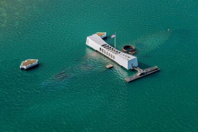
This section calls for a quieter response than the beach and harbor views. From above, the crater’s form is clear, but the place is also a memorial, not simply a scenic landmark. I appreciate that it appears in the route because it adds a meaningful layer to the flight and reminds you that Oahu’s story includes military history as well as tourism.
The helicopter also passes the H-1 and H-201 interchange area. The H-201 section between Route 99 and the western H-1 interchange remains designated as Route 78. Those details may sound technical, but the roads help explain how Honolulu connects its waterfront districts with the central and western parts of the island.
From the ground, freeway interchanges can look like a tangle of ramps. From the air, their structure becomes easier to read. This is not the most scenic part of the flight, but it gives you a better understanding of the island’s transport network.
Moanalua Gardens and the H3 mountain crossing
Moanalua Gardens is one of the more distinctive inland points on the route. This 24-acre privately owned public park is home to the Kamehameha V Cottage, once used by Prince Lot Kapuāiwa, who later became King Kamehameha V.
The park also hosts the annual Prince Lot Hula Festival and contains a large monkeypod tree known in Japan as the Hitachi tree. You may not be able to pick out every detail from the helicopter, but the pilot can provide context as the route passes over the area.
The H3 Highway gives the flight a dramatic change in setting. Also called the John A. Burns Freeway, H3 crosses the Koʻolau Range using viaducts and tunnels, including the 5,165-foot Tetsuo Harano Tunnels and the smaller Hospital Rock Tunnels.
This is one of the best reasons to choose this route instead of a flight focused only on Waikiki. You get a sense of Oahu’s interior and the scale of the mountain crossing. The highway’s engineered path through the range creates a strong contrast with the coastal parks and city streets seen earlier.
I would pay close attention during this portion, since the route offers a quick lesson in Oahu’s geography. The flight does not only show you the shore. It connects the built-up south coast with the mountains and central parts of the island.
Aloha Stadium and the return to HNL
Aloha Stadium appears toward the western side of the route before the helicopter returns to HNL. The stadium is in Halawa and was once the largest stadium in Hawaii. As of December 2020, it stopped hosting fan-attended events indefinitely and placed a moratorium on new events.
Seeing it from the air gives you a useful final landmark before returning to the airport. It also brings the route back to the practical side of Oahu, with roads, transport links, and major civic sites rather than just resort scenery.
The itinerary covers a lot in half an hour. You see beaches, marinas, a volcanic crater, a private golf course, downtown, a memorial cemetery, gardens, highways, mountains, and a stadium. That range is the main value of the tour, though it also explains why every view is brief.
What the $319 price really buys
At $319 per person, this is not a casual add-on for most budgets. The price makes more sense if you want an experience that combines several parts of Oahu in one flight and gives you views that are difficult or impossible to obtain from roads and trails.
The maximum-three-person format improves the value. You are not paying for a seat in a large aircraft filled with people competing for the same view. The small cabin also supports the personal service praised in the feedback, with pilots such as Scott, Stefan, and Jacob described as friendly, attentive, and thorough.
The short length is the main limitation. If you want a long, slow flight around the entire island, this is not that product. The route is concentrated around Honolulu and central Oahu, with the coast, Waikiki, Diamond Head, and the H3 corridor receiving the main attention.
I would compare the cost with what else you want from your Hawaii budget. If you already plan several expensive activities, the helicopter ride may feel hard to justify. If aerial photography, a special occasion, or a once-only view of Oahu matters most, the small group and broad route make the price easier to defend.
Doors-off flying, photos, and comfort
One of the clearest tips from the feedback is to consider flying with the doors off. That setup can give you cleaner views and fewer reflections for photographs. It also changes the feel of the flight, making the experience more open and direct.
You should confirm the available configuration when booking rather than assume it is guaranteed. The supplied details identify the tour as a helicopter experience and include a phone lanyard, but they do not state that every departure is doors-off.
The lanyard is useful because phone photography in a helicopter requires care. Use the provided safety item, listen to the pilot, and keep your equipment secure. The headset lets you follow the commentary without guessing what you are looking at.
The small cabin is a plus for visibility, but helicopter seating can still affect what you see. Since the information provided does not promise a particular seat, I would avoid booking this solely for one exact photograph. Enjoy the route as a moving series of views.
Who will enjoy this flight most
I would recommend this tour to people who want a compact overview of Honolulu and central Oahu, especially if they value a small group and aerial photographs. It suits couples, families, and small parties who want a memorable activity without spending most of a day away from other plans.
It is also a good fit if you have limited time on Oahu. In 30 minutes, you see far more of the island’s structure than you can cover on foot around Waikiki. The pilot commentary helps turn the ride into a short geography and history lesson rather than a silent loop in the sky.
People who dislike flying, have strict weight concerns, or want a slow and detailed look at every attraction should consider the limitations carefully. The route moves fast, the activity depends on good weather, and the price is high for the duration.
Booking ahead is sensible. The experience is booked an average of 32 days in advance, which suggests that popular dates can fill well before your holiday. Confirmation is provided at booking, and the activity returns to the starting point.
Cancellation is free until 24 hours before the start time. Inside that window, no refund is provided and changes are not accepted. If poor weather cancels the flight, you can receive a different date or a full refund. The same choice applies if the minimum number needed to operate the experience is not met.
Should you book this Oahu helicopter tour?
Book it if you want a small, personal flight with a wide route and strong photo potential. The combination of Waikiki, Diamond Head, Honolulu Harbor, Punch Bowl, Moanalua Gardens, H3, and Aloha Stadium gives you a sharper sense of Oahu than a beach-only outing.
Skip it if $319 feels too high for 30 minutes, or if you would rather spend that money on an activity that keeps you on the ground longer. If you do book, reserve early, check the 300-pound passenger limit, ask about doors-off flying, and keep your phone ready but your attention on the view.
FAQ
How long is the helicopter tour?
The flight lasts approximately 30 minutes.
Where does the tour begin and end?
It begins at 1 Lagoon Drive, Honolulu, Hawaii 96819, at HNL, and ends back at the same meeting point.
How many people can join the tour?
The activity has a maximum of three travelers.
What is the price?
The listed price is $319 per person.
Is the tour offered in English?
Yes. The experience is offered in English.
What equipment is included?
An aviation headset and a cell phone lanyard are included.
Is there a passenger weight limit?
Yes. The total weight limit is 300 pounds per passenger.
What happens if bad weather cancels the flight?
You will be offered a different date or a full refund.
Can I cancel for a refund?
Yes. You can cancel at least 24 hours before the start time for a full refund. Cancellations within 24 hours are not refunded.
Just added around Oahu
- Oahu: Waikiki 20-Minute Doors On / Doors Off Helicopter Tour★ 4.9 · 32 reviews
- Day Trip fr Oahu to Kauai: Highlights & Movie Sites w/ Helicopter★ 4.0 · 10 reviews
- Oahu to Big Island : Big Island Volcano Helicopter Tour & Hilo 1 Day Tour★ 4.0 · 10 reviews
- Blue Skies of Oahu Helicopter Tour★ 5.0 · 50 reviews
- 60 Minutes SHARED Helicopter Tour in Honolulu★ 5.0 · 46 reviews
- Complete Island Oahu Helicopter Tour★ 4.5 · 35 reviews
- 18 Minutes PRIVATE Helicopter Tour in Honolulu★ 5.0 · 19 reviews
- 18 Minutes SHARED Helicopter Tour in Honolulu★ 5.0 · 34 reviews
Oahu Helicopter Tours, compared.
Magnum PI Hughes 500 4-Passenger Doors-Off Helicopters
Read our review →
Private Oʻahu Helicopter Experience: All Window Seats
Read our review →
Path to Pali 30-Minute Doors On or Off Helicopter Tour
Read our review →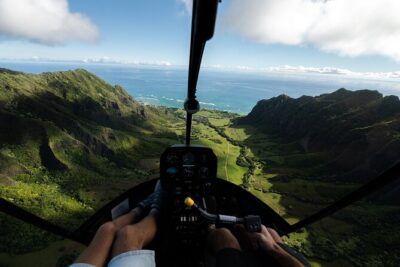

Browse the lists this tour appears in